Arctic Stakeholder Map
The KEPLER Interactive Stakeholder Map is an exploratory application, developed during the KEPLER project. The map provides an overview of Arctic activities and linkages to the European Union’s Copernicus programme.
The platform is now live, check it out at map.kepler-polar.eu – a direct link is also available via the menu above.
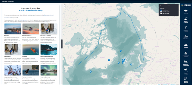
The Arctic Stakeholder Map database contains stakeholder interests from KEPLER, Copernicus and other relevant data streams*. The development of an Application Programming Interface allows users to access and display data in a visual map format, and view links to direct data sources for a more in-depth search.
*i.e. Fisheries, Search and Rescue, Research and Climate, Arctic shipping- including Icebreaker vessels, Government Agencies, Indigenous Communities, Tourism/Wildlife and Operational Weather Services.
Development and input of the map is ongoing, administrators continue to modify and add new items, external resources and CSV data. We hope that this map will be a legacy of the KEPLER project and plan for this platform to be utilised through other projects such as Arctic PASSION, and maintained by the EU Polar Cluster.
Further information about Arctic activities and linkages to the EU Copernicus programme can be found in the KEPLER Roadmap. The recommendations within the KEPLER roadmap aim inform the next phase of the Copernicus programme, aiming to improve information services, and tackle the issues facing users in polar regions.
We would love to hear your feedback about this new platform- you can get in touch via the contact button on the menu above.